
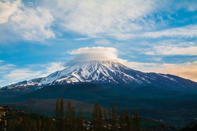
Damavand Cloud Cap
The shape of clouds that form atop Mount Damavand is a topic of interest among our mountain climbers. For instance, here is a photograph of a cap cloud.
Damavand Cloud Cap
This spectacular formation is a Cap-cloud. Cap cloud or cloud cap is a form of layer clouds (also called stratiform clouds) that appear over mountaintops.
They are a result of upper-level winds that breeze horizontally to condense the moist air; therefore the clouds take the shape of a lentil. A cap cloud is also sometimes called a “pileus;” which is the Latin term.
Credit goes to NASA for this breathtaking photo of Damavand’s mountain top. It looks like it is wearing a hat!
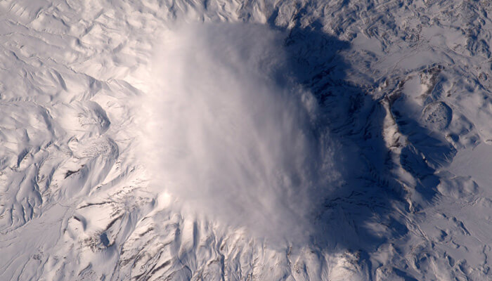
Damavand peak from the space station
Cap Clouds on an Isolated Mountain Peak
Usually, cap clouds form over isolated and high mountain peaks. These are a form of layer-cloud, also called stratiform clouds, that take shape as the temperature suddenly plummets.
The sudden drop in temperature causes a rapid condensation of the moisture that is present naturally in the air. As a result of the wind that blows quite a way atop the mountain, this condensate forms a lentil-shaped cloud.
Damavand is higher than all other mountains in Iran, and it is an isolated peak. This means that there are no tall landmasses near it that can deter the wind that blows toward or around it.
Direct and unhindered gusts of wind can therefore produce interesting shapes of clouds. PHOTO OF DAMAVAND WITH A CAP
Scientific Discourse
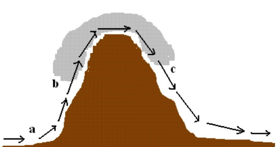
The gust of air that moves toward a mountain, will inevitably ascend to the top. This is called the Anabatic wind. As it rises, its temperature and pressure both fall.
This process lasts from the base until halfway up the slope. By the time it gets halfway up, due to the condensation rate, the water can no longer remain as vapor and must appear as an opaque mass of tiny water droplets. These we call clouds.
The mechanism is the same as on cold winter days when our exhalation forms a fleeting cloud. PHOTO OF A PRETTY SCARF CLOUD
After this, the cold condensate continues its travel up the face of the mountain until it reaches the peak.
Through the process of condensation, the energy levels of the particles that form the cloud, increase. The wind continues to travel with vapor that has slightly higher energy, but now it has reached the peak and has slightly passed it too; which means the temperature is rising again as well and the pressure has increased too.
Thus, the cloud loses some of its mass due to molecules vaporizing.
The continued addition of vapor and loss of it results in the formation of a rather stationary cloud over the peak; between the layers of which, gusts of strong wing move freely.
Therefore, two opposing mechanisms of condensation and vaporization occur at the mountain top and make for the stunning cap cloud whose photographs we have studied above.
And yet, it seems as though the process is not fully explained; After all, why doesn’t the gust of wind pass over the peak and just continue its way downslope all the way?
Why does it turn back and form a conical flow around the upper face?
The answer becomes clear by studying the Bernoulli principle in fluid mechanics. Based on Bernoulli’s principle, the speed of a fluid changes inversely proportional to its pressure.
Therefore, the outer layers of the air that surround the face of the mountain are more stationary, pressing the speedier layers inside, and near the face.
So long as the gusts are mild enough to retain a balanced flow, the wind prefers to move near the surface and at the top.

