Geoparks
According to the definition demarcated by UNESCO, a geopark is an enclosed area with determined borders that comprises a number of sites that possess geological significance and can play an important role in the economic development of the community nearby.
Furthermore, a geopark may contain historical, ecological, archeological, cultural, and other features as well as its geological import.
UNESCO initiated the UNESCO Global Geopark label in answer to the need for global planning to recognize geologically significant sites.
The aim of the UNESCO Global Geoparks was to emphasize the value of these sites, as well as create jobs and boost the regional economy. With these ends in mind, UNESCO ratified this global label in the year 2015.
UNESCO Global Geopark works in coordination with “UNESCO World Heritage Site” and “The UNESCO World Network of Biosphere Reserves.”
Global Network of Geoparks
For a geopark to be included in the Global Network of Geoparks, it must possess the following features:
- A management plan for the sustainable socio-economic development of the locals(often based in Agritourism, i.e. Agricultural Tourism, and Geotourism, i.e. Geological Tourism).
- Devise methods of protection and conservation of local geological sites and provide the tools for education regarding geology and further environmental matters.
- Execute tasks and commissions in harmony with local authorities, indigenous communities, and private corporations in order to produce the best possible strategies in preserving the earth and to consolidate the ideals of sustainability with all action plans.
The Qeshm Geopark is the first of its kind in the Middle East to join the UNESCO global network of geoparks.
At the current time, among Asian countries, China has the largest number of geoparks.
Global Registration of geoparks
Years of arduous planning and preparation are required for a site to be registered among the UNESCO Global Network of Geoparks.
During this time, information can be gathered regarding the preservation of landmarks, management of the area, and geotouristical monetization. All of this calls the attention of tourism companies and travel agencies.
A collection of interesting landmarks does not suffice to produce a geopark. Prior planning, preliminary undertakings, and most importantly, instigating sustainable and profitable local businesses are all required for an area to meet the qualifications for a registered geopark.
A candidate area for a geopark must be built and managed by the efforts of the local community.
Iran’s Geoparks
Iran has the potential for many geoparks. The most prominent landmarks of this country include Magma phenomena, Tectonic landforms, salt plains, erosion landforms, mountains, deserts, caves, and mud volcanoes, which in total, produce a precious body of geological forms.
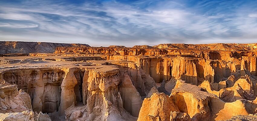
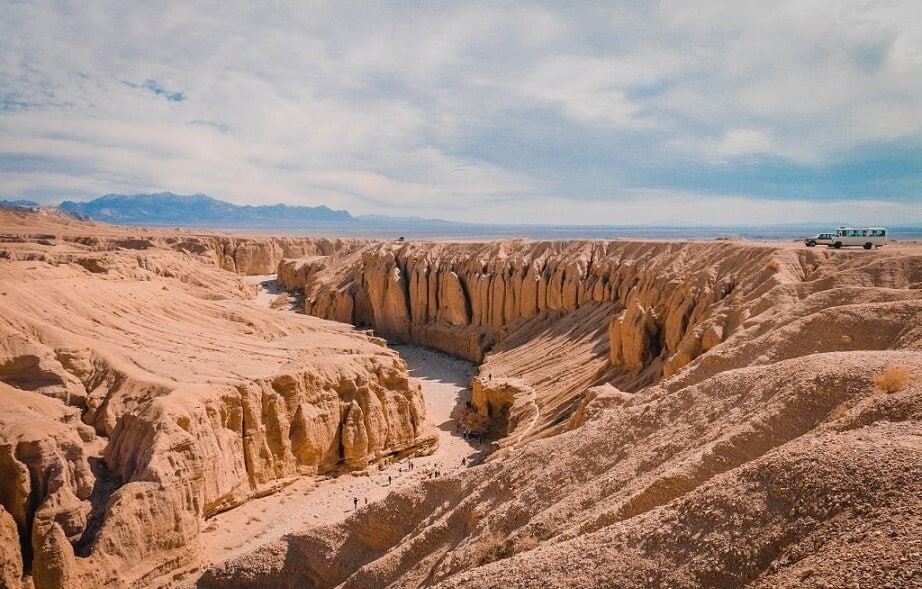
Qeshm Geopark is the first geopark of the Middle East and the only geopark of Iran to join UNESCO’s global list of geoparks.
Sadly, there have been cases in which a geopark has exited the UNESCO Global List due to dwindling efforts and not meeting minimum requirements.
However, there are other sites in Iran undergoing preparations, readying themselves for UNESCO validation.
These soon-to-be Geoparks include the Aras Geopark, Tabas Geopark, Geno Biosphere Reserve, and Raggeh Geopark.
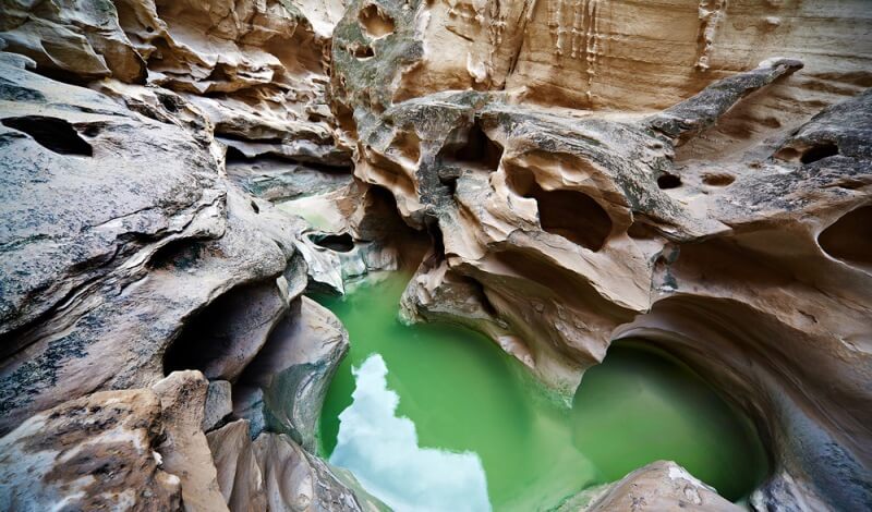
Qeshm Geopark
Qeshm Geopark was registered in the UNESCO list for the first time in 1385, however, it was removed from the Global List in 1391, until with renewed efforts of the authorities, it was registered again in 1395. Qeshm Geopark comprises 25 geosites.
The Qeshm region and its geopark are very warm in both summer and winter. During most of the year, the weather is humid and hot; which is bothersome at times, especially between Mehr – Farvardin.
The warmest time of the year is halfway through Tir until the middle of Shahrivar, and the coldest time of the year falls between Day and Bahman.
In spite of its relatively small area, the Island of Qeshm has substantial biodiversity. 16 species of mammals inhabit this region; most of them can be observed from within the Qeshm Geopark.
This number excludes the marine mammals that sometimes swim near the Island shore.
Birds, likely the most eminent of Qeshm’s animal species, are plentiful and diverse. 226 species of birds either live in the region or migrate there for certain periods during the year.
Since Qeshm is located in a subtropical area, it is not rich in vegetation. For the most part, it contains shrubs which grow at distant lengths.
There are, of course, areas in which plants have grown in clusters. The most dense area of vegetation is the Hara Mangrove Forest, located inside the Qeshm Geopark and comprising one of its most distinguished features.
Qeshm is the largest island of the Persian Gulf, located at the south of the coastal cities of Bandar Abbas and Bandar Khamir. Approximately 60 towns reside on the island of Qeshm, most of them with access to the shoreline.
Qeshm possesses a rich culture and history and dates back to before Islam, which is evident in the cultural diversity of the community. Ostensibly, Qeshm harbored prosperous towns ever since the era of Elamites, and the name Qeshm itself has its roots in Hatamtite (i.e. the extinct language of the Elamites).
Qeshm Geopark Address: Western shores of Qeshm Island, Iran.
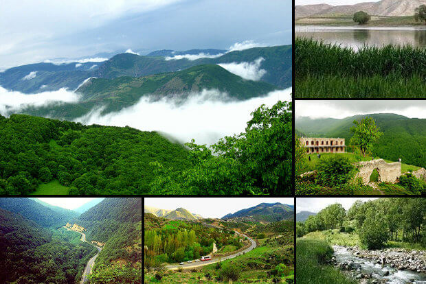
Aras Geopark
Aras Geopark is located at the northwest of Iran, along the northern region of the province of East Azerbaijan. The Geopark is located precisely within the bounds of the city Jolfa.
The continuation of the mountain range Lesser Caucasus is located in this region. This mountain range and the mountain ranges of Alborz and Zagros comprise the middle of the Alpine-Himalayan orogenic belt which spans from Europe to Eastern Asia and like a natural wall, has created diversity in the climate and ecology, and culture of both sides.
The origin of the precipitation in this area is the humid Mediterranean wind that enters the area from the middle of autumn until the middle of spring, from the west.
The average yearly rainfall is 250-350 mm.
The region of Aras Geopark is famous for its latitudinal diversity which results in the possibility of different climates existing within its bounds.
The highest point in the Jolfa region is Mount Kiamaky, with its peak at 3347 meters. The lowest point is in the northern part of the region, in the valley of the Aras River. This valley is located at a latitude of 720 at the point that it joins the Chai River, which together forms the western border of the geopark. Due to its phenomenal climate, this area is also diverse in its vegetation.
While the valley of Aras River is filled with subtropical trees, the western and middle regions are covered in the steppe, and the slopes of the eastern mountains are covered with thick closed-canopy forests. The permanent snow line sits at a latitude of 3000 meters.
This diversity in the vegetation and ecology causes Aras Geopark to be of huge interest for Geotourism, making it highly notable in the natural world heritage web.
Aras’ case was sent to The List for Global Network of Geoparks in 1389, however, after evaluation in the year 1390, the area was not deemed eligible for the label of Global Geopark.
What made the site not quality was determined to be the lack of involvement of the local community in the growth and decision-making of the geopark. It was decided that after fixing the lacking areas, the park must reapply to be included in the Global Network.
Ever since then, 7 geosites have been added to the collection of Aras, bringing the number of its components to 24; and the project has momentarily come to a halt. The number may yet increase in the future with renewed efforts of the community and authorities.
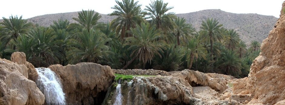
Geno Biosphere Reserve
Geno Biosphere Reserve is located in the Hormozgan Province, in the south. Most of the area of this reserve is located inside mountain ranges.
The climate of the province is overall hot and humid, even though there are mountains with cold and wet weather located within its bounds. The mountains cause much of the precipitation of the province. One of these mountains is the Geno of Bandarabbas with a height of 2347 meters.
The best time of year to climb this mountain, especially for non-indigenous climbers is late autumn until the beginning of spring. The climate of the Geno region and overall, Bandarabbas Province is relatively mild during this period.
Late autumn and winter often make for too harsh a weather for climbing other heights of Iran, and it would call for professional gear and experienced climbers. At this time of year, however, Geno remains an apt choice for a safe climb.
The noteworthy topographical features of Geno:
Geno Biosphere Reserve possesses rich green vegetation on the slopes due to heavy snowfall at its summit.
Because of its geographical location and its quick increase in latitude, diverse microclimates have formed in different geographical directions. The valleys and slopes of Geno Biosphere Reserve harbor fantastically diverse vegetation.
Tabas Geopark
Another site currently undergoing preparations for evaluation to join the Global Geopark List is the Tabas Geopark, which is the only one of its kind.
The region comprises low meadowlands, salt plains, and mountain ranges. Moving sand dunes and thick forests of saxaul compose the unique assembly of the area.
Since the historic Silk Road passed through this land, many unmissable caravanserais existed in the region whose remains stands there to this day since times long passed.
Naybandan Wildlife Sanctuary is one of the most well-protected reserves of Iran, with complete protection against monetization and interference of industry and agriculture decision-makers.
This Sanctuary resides inside the bounds of Tabas Geopark and creates a fairly untouched area for the wildlife.